Introduction
In late February 2021, the Northern Valleys of the Murray Darling Basin (Gwydir, Namoi, Macquarie, Barwon Darling and Border Rivers) received significant rainfall. We closely monitored this event to analyse flows, river extractions, and take from other sources (e.g. floodplain harvesting).
Employing a mix of remote sensing technologies (i.e. satellite observations) and elevation data, we used and refined the method used in the early 2020 ‘First Flush Flows’, to replicate the same analysis over a similar geography.
In doing so, analysts estimated both the filling period and volumes of water held in private storages for the nominated ‘event’ duration. Combining these analyses with water account and hydrometric station data gives a consolidated event summary.
Results
Results from remote sensing analytics show an observed total event increase from all forms of take of nearly 427 GL of water put into private storages between late-February and mid-April 2021.
This includes 206 GL that was taken through a meter and with a water licence, and around 221 GL from other forms of take, including floodplain harvesting.
These figures are constrained to only storages that could be observed in cloud free imagery, and to only storages with a known storage curve. The volumes are scaled down to account for inaccuracies in the analysis, making it even more conservative. Therefore, the actual stored volumes may be substantially higher in some catchments.
Consolidated totals for the five valleys are in Table 1 below.
| Northern Valleys | Pre-event 21-Feb to 13-Mar-21 | Mid-event 18 to 31-Mar-21 | Post-event 2 to 14-Apr-21 | |
|---|---|---|---|---|
| Number of storages | Wet | 677 | 560 | 1,002 |
| Dry | 485 | 183 | 165 | |
| No image | 7 | 426 | 2 | |
| No curve | 245 | |||
| Total | 1,414 | |||
| Volume | Volume in storage (GL) | 182 | 184.1 | 609.6 |
| Full supply volume (FSV) (GL) | 1,179.4 | |||
| % of FSV | 15% | 16% | 52% | |
To complement the remote observations, we assessed metering information for the regulated river water sources within the floodplain management areas (Table 2). We used water orders to apportion the measured usage to the periods assessed for storage volume change.
This shows up to 32% (Macquarie), 65% (Namoi), 35% (Gwydir) and 49% (Border Rivers) may have been supplied by regulated river water source extractions. The additional volume change could be made up of unmetered floodplain harvesting and unregulated take, direct and on-farm rainfall run-off/tailwater capture, stock and domestic take, groundwater take, or an artefact of uncertainty and limitations in the remote sensing method. The largest of these potential sources are considered to be unmetered floodplain harvesting and unmetered unregulated river extraction. Overall, across the Northern Basin, the metered water take volumes for Barwon Darling tributaries account for 43% of the total water take estimated by remote sensing (Table 2).
| Floodplain management area | River extraction water source1 | Consumptive licence use (GL)2 | Date from | Date to | Floodplain management area storage change (GL) | % of volume change |
|---|---|---|---|---|---|---|
| Border Rivers | NSW Border Rivers Regulated | 393 | 3-Mar-21 | 2-Apr-21 | 79 | 49% |
| Gwydir | Gwydir Regulated | 82 | 21-Feb-21 | 12-Apr-21 | 232 | 35% |
| Namoi | Lower Namoi Regulated | 41 | 3-Mar-21 | 14-Apr-21 | 63 | 65% |
| Macquarie | Macquarie and Cudgegong Regulated | 7 | 13-Mar-21 | 2-Apr-21 | 22 | 32% |
| Total | 169 | 21-Feb-21 | 14-Apr-21 | 396 | 43% | |
| Barwon Darling | Barwon Darling unregulated | 374 | 1-Mar-21 | 5-Apr-21 | 31 | >100% |
| Total | 206 | 21-Feb-21 | 5-Apr-21 | 427 | N/A | |
1 Usage assessed downstream of Dumaresq–Macintyre junction (Border Rivers), downstream Pallamallawa (Gwydir), downstream Gunnedah (Namoi), downstream Dubbo (Macquarie)
2 Excludes held environmental water use and river extractions from unregulated river water sources other than the Barwon Darling. Extractions for regulated river water sources include water access licence use for supplementary, general security and high security access licence categories.
3 Excludes NSW allocation extracted in QLD. Excludes QLD allocation extracted in NSW (no information was available at the time of analysis)
4 Estimated volume for the remote sensing analysis period of 1 March 21 to 5 April 21. Provisional Barwon Darling consumptive extractions for the 2020-21 water year at time of analysis was 192 GL. This excludes held environmental water access licence orders. The estimate considers potential flow access under the water sharing plan flow rules for the analysis period, and apportions the total use based on days of access. Variance to the flow access rules for environmental orders are not considered in this estimate.
Flows
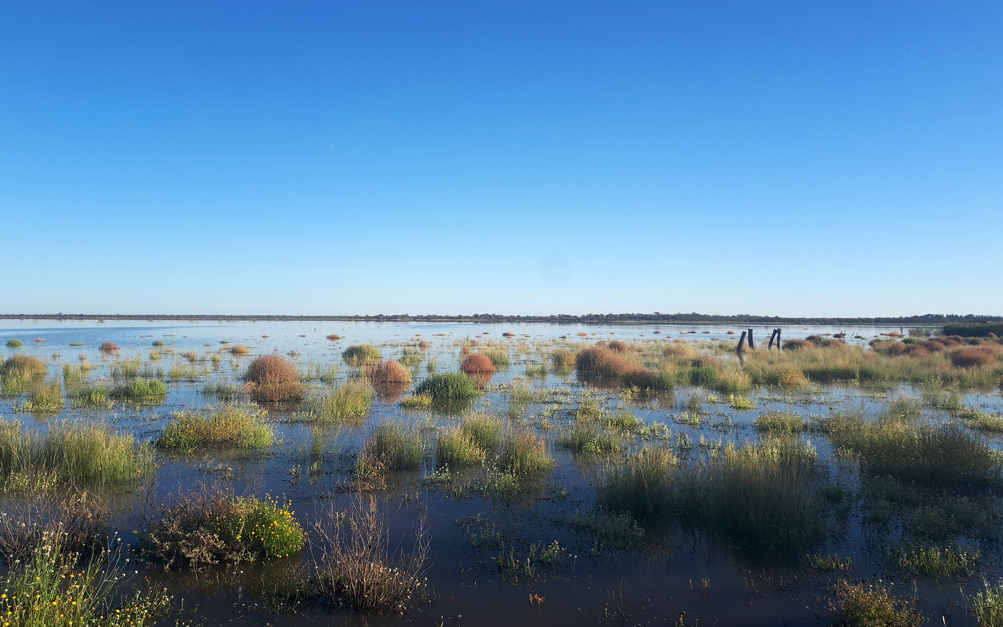
Substantial flow from the event transitioned through the Barwon Darling river system to the Menindee Lakes. The long travel times for flow in this system need a wider period of observation to illustrate the full outcome of such flow events. For the period 1 February 2021 to 30 June 2021 over 1,500 GL flowed through Walgett, and over 1,100 GL through Wilcannia.
Flow gauging stations in the connecting tributaries show large volumes flowing to the Barwon Darling from the Gwydir (406 GL)5, Border Rivers (391 GL)6, Namoi (156 GL)7, and Macquarie, Castlereagh and Bogan rivers (170 GL)8. Volumetrically, these are likely conservative, particularly for the Gwydir, given the large volumes observed in the Barwon Darling, and the limitations of high flow measurement when flows break over the floodplain in the northern valleys. Significant flows were also transitioning to the Barwon Darling from the Culgoa (150 GL)9 and Moonie rivers (100 GL)10.
Within this period the combined Menindee Lakes storage volume increased by 767 GL and was continuing to rise as further flow transitioned through. Additionally, 109 GL was released from the lakes providing flow through to the Murray River.
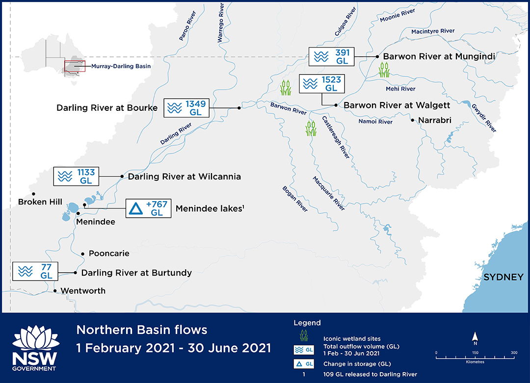
5 Includes Gil Gil Creek at Galloway (416052), Mehi River at Bronte (418058), Moomin Creek at Moomin Plains (418070), Thalaba Creek at Belarre. Excludes Gingham Channel, where a further 67 GL was measured flowing to the lower Gwydir floodplain
6 Barwon River at Mungindi
7 Includes Namoi River at Goangra, Pian Creek at Waminda
8 Includes Castlereagh River at Gungalman (420020), Macquarie River at Brewon Bridge (gap filled) (421907), Marra Creek at Billybingbone Bridge (421107), Bogan River at Gongolgon (421023)
9 Culgoa River at downstream Collerina (422006)
10 Moonie River at Gundablouie (417001)
While a substantial volume of water was stored through floodplain harvesting and unregulated take, this has occurred during a wet period when there are large volumes of water on land and in rivers, enough to replenish and re-fill weir and refuge pools, wetlands, and the Menindee Lakes. This analysis underscores the department’s management of water resources, including through the protection of first flushes, by understanding and quantifying take, and ultimately permitting floodplain harvesting only during wet periods when downstream critical human and environmental needs will be fully satisfied.