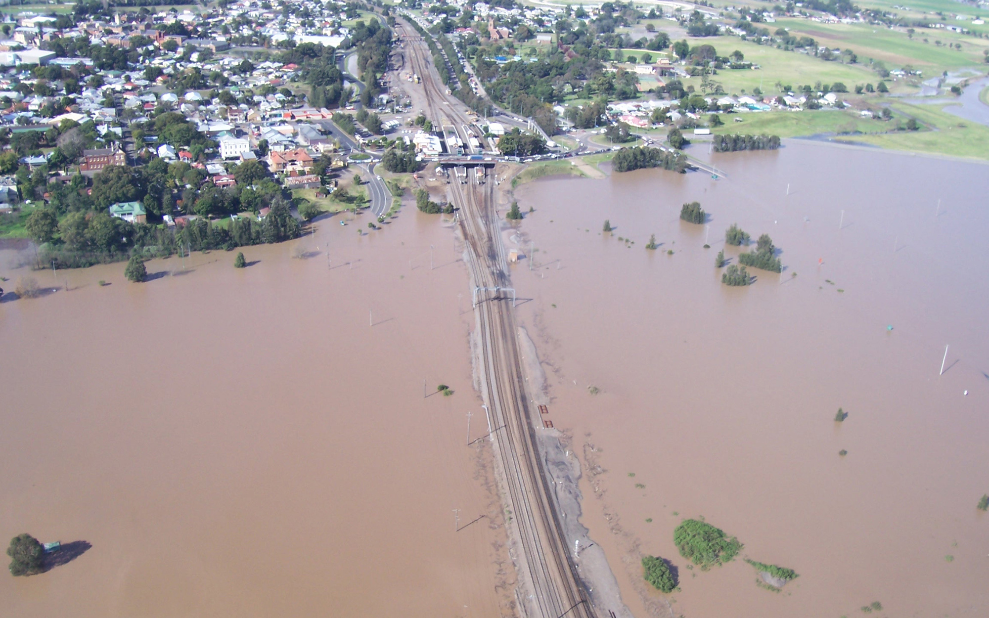
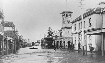
The Hunter Valley Flood Mitigation Scheme (HVFMS) is undertaking asset inspections and clean-up activities following the May 2025 flood event.
- For emergency flood assistance, call the NSW SES on 132 500
- If your life is at risk, call Triple Zero (000) immediately
- For real-time road closure updates, visit: Live Traffic
- For school impacts, visit: NSW Department of Education School Operational Status
- For safety, property, or livestock movement assistance, call the NSW SES on 132 500 or visit: NSW SES
- If you have concerns about water entering through a flood gate, please contact us on 1300 081 047.
Flood Gate Update
Water levels in the main rivers are receding, allowing flood gates to discharge water from the floodplain back into the river channel.
Flood gates operate based on water pressure. When the water level on the landward side becomes higher than the riverside of the levee, the gates automatically open to allow drainage. If river levels rise again, the gates will be forced closed and will remain shut until the river levels fall.
About the scheme
The Hunter Valley Flood Mitigation Scheme is designed to mitigate flood risk as an integrated system operating across multiple local government areas, covering urban, peri-urban and rural areas. Today the scheme provides a level of benefit for over 250,000 people in the Hunter Valley. The scheme management has transitioned from a traditional approach to infrastructure construction, to a holistic approach to floodplain management and disaster risk reduction implemented by best practice asset management systems.
How the flood mitigation scheme works:
- The scheme provides protection for people, property and infrastructure.
- Levees and controlled floodways protect rural areas and major towns from minor to moderate flooding.
- Maitland floodways divert major flows in a controlled manner around the city.
- Levees provide a reduction in flood damages to towns in moderate to major floods and rural lands in minor floods.
- Channels and floodgates allow the removal of floodwaters from farming land over time, reducing negative impacts on local landholders.
Hunter Valley Flood Mitigation Scheme
Watch the video to learn more about the Hunter Valley Flood Mitigation Scheme.
Morpeth Levee repairs
Watch the video to learn about the permanent repair works that are well underway to strengthen the Hunter Valley Flood Mitigation Scheme.
More about the Hunter Valley Flood Mitigation Scheme
Information on flood response and recovery.
Learn more about upcoming Hunter Valley Mitigation Scheme major projects.
Aboriginal people have occupied the Hunter Valley for tens of thousands of years. Culturally important heritage sites, places and landscapes
Planning and development controls
Information on local flood planning, development and responsibilities
Any proposed development works (including fences) located in, on or adjacent to levees or within declared floodplains (as gazetted under the Hunter Valley Flood Mitigation Act 1956) must be referred to Department of Climate Change, Energy, the Environment and Water for consideration under Section 256 of the Water Management Act 2000.
For information about what you can and cannot do around Hunter Valley flood Mitigation Scheme infrastructure, please read: Requirements for development in the Hunter Valley Flood Mitigation Scheme
If you are a developer you will need council approval. Council will refer the plan to the department. You should consult with the department before submitting the final plans as this will avoid unnecessary amendments at a later stage.
The NSW Flood Data Portal also has information on flood planning and development.
Information about flooding in your area and development controls can be found on your local council website:
City of Newcastle
Maitland City Council
Port Stephens Council
Singleton Council
Upper Hunter Shire Council
Flood event contacts
Emergency call 000
Bureau of Meteorology (BOM)
The BOM website provides the community with access to weather forecasts, severe weather warnings, observations, flood information, marine and high seas forecasts and climate information.
Phone: 02 9296 1555
Hunter Forecast (BOM)
For up to date regional information.
State Emergency Service (SES)
NSW SES is the lead combat agency in flood, storm and tsunami emergencies.
Emergency call 132 500
Search their site by suburb for storm, flood and tsunami risk and advice for your area on how to plan and prepare for disasters and bad weather, what to do during the flood or storm and steps to recovery once the disaster is over.
Roads and Maritime Services
Phone 132 701 for information on road closures or see live traffic updates.
Hunter Local Land Services
Emergency call 1300 795 299 or go to the website.
NSW Department of Primary Industries
Responsible for the coordination of agriculture and animal services in emergencies.
Funding and management
The scheme assets are owned by the Water Administration Ministerial Corporation and are managed under delegation by the Department of Climate Change, Energy, the Environment and Water. Scheme assets are located on private land.
Hunter Local Land Services contributes to the maintenance budget, as required by the Water Management Act 2000. This Act repealed the Hunter Valley Flood Mitigation Scheme Act 1956.
Hunter Local Land Services' share is funded by the Hunter Catchment Contributions. Local government ratepayers in the Hunter catchment pay an annual levy, known as Hunter catchment contributions. Local councils also provide a small contribution. Chapter 5 Public Works – Part 2 of the Water Management Act refers directly to Hunter Valley Flood Mitigation works. Works are approved under Part 5 of the Environment Planning and Assessment Act 1979.
The department is responsible for all maintenance activities of scheme assets. Maintenance activities include:
- levee mowing
- spraying of aquatic and terrestrial weeds
- cleaning of drains
- floodgate repairs.
In some cases, drainage channels extend beyond the department's jurisdiction and we have no authority to undertake any works in these areas.
We also contract other agencies and organisations to do work on their behalf. This can include project design and management, construction work, assessment of environmental factors and stakeholder engagement.
Flood management assets and activities
Over 2000 individual assets are maintained along the rivers and floodplains.
Levee
An embankment providing a reduction in in flood damages to towns in moderate and major flood events and the rural areas in minor events.
Drainage Channel (or drains)
Control discharge of floodwaters from the river spilling into defined floodways.
Control and diversion banks
Reduce the potential damage by controlling the speed, direction and depth of floodwaters. These are located on the Bolwarra, Oakhampton, Swan Reach and Raymond Terrace floodways.
Floodgate
Prevents backflow from the river as water levels rise during flood events and releases water from drains and creeks after flood waters recede.
Floodway
Part of the natural floodplain allowing diversion of floodwaters away from the main river channel during a flood and which is often a naturally defined channel. If these areas are blocked they can cause a significant change in flood flow, direction and levels, affecting other areas.
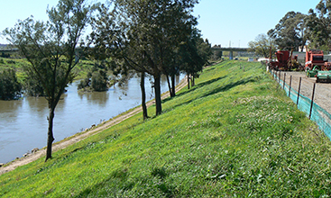
Bank stabilisation and protection works
Protection works stabilise and protect surrounding river banks from erosive flood waters, which in turn protects the levee assets.
River or stream banks without vegetation will continue to be unstable if the toe of the bank, where the levee meets the original surface foundation, continues to wash away.
Vegetation within the levee protected zone is limited to grass or low ground coverage. OEH does not permit planting of trees or shrubs within the protected zone.
River Bank Protection WorksProtect the river bank from erosion; this helps to maintain and stabilise the levee.
|  |
Control Banks and BasinsReduce potential damage by controlling the velocity, direction and depth of floodwaters.
|  |
Drainage ChannelsRemove floodwater by directing the water back to the river.
|  |
FloodgatesPrevent the backflow of water to the landscape during a flood. As the river height goes down floodgates allow the water to return to the river.
|  |
FloodplainsLow-lying landscapes adjacent to a river which inundate when the river is in flood.
|  |
LeveesContain rivers and/ or mitigate floodwaters in a flood.
|  |
SpillwaysDivert excess floodwaters through defined flood ways.
|  |
Report damage
To report any damage to the Hunter valley Flood Mitigation Scheme please use the QR code, alternatively you can use the link below or contact us.

Contact us
General enquiries
Phone: 1300 081 047 or send us a message.
For emergency flood assistance call the SES: 132 500
If your life is at risk, call 000.