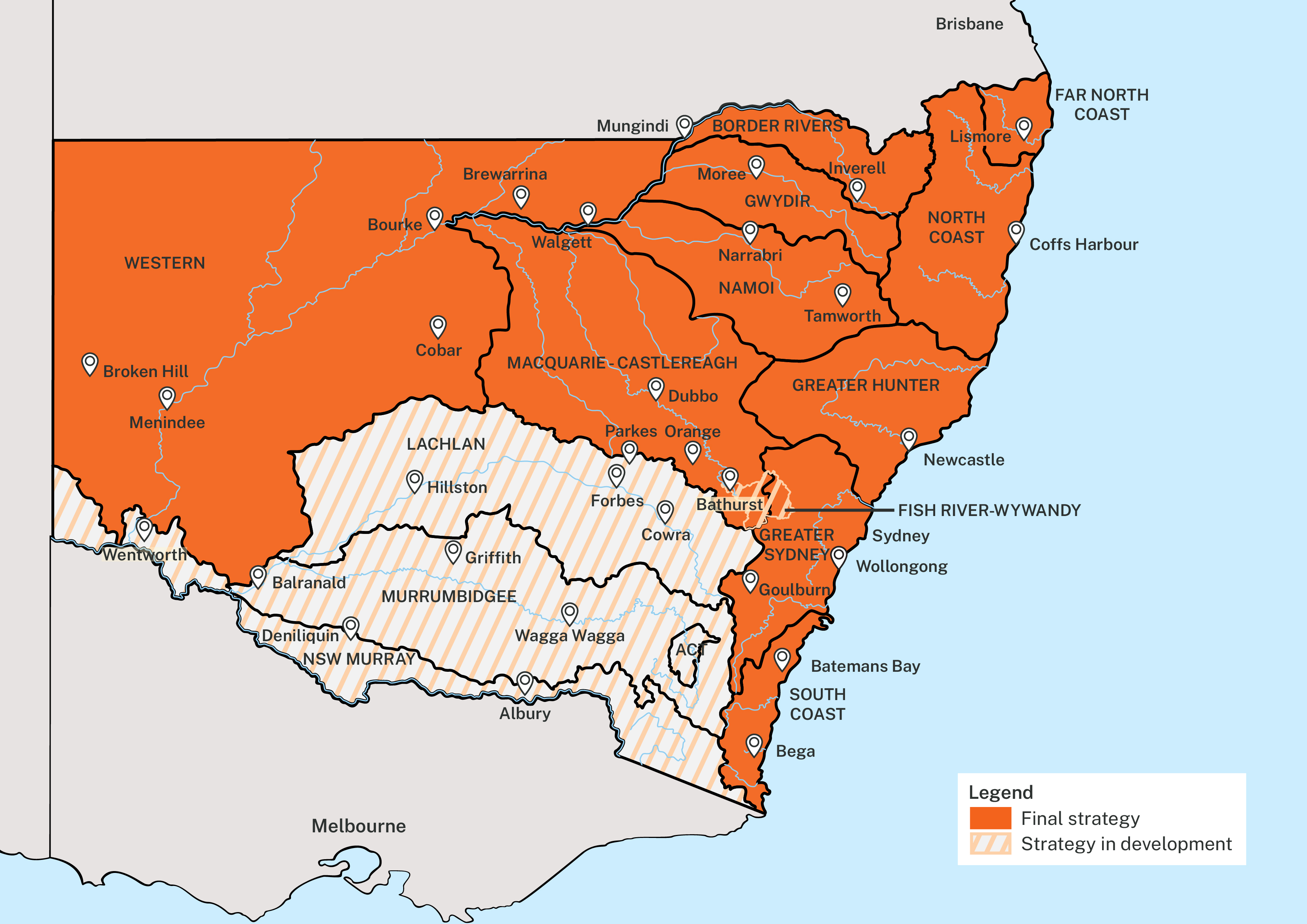
Regional and metropolitan water strategy program status
Since 2022, 9 regional water strategies and 2 metropolitan strategies have been finalised with implementation underway. An additional 4 regional water strategies are under development including initial consultation on the new Fish River-Wywandy Regional Water Strategy. This strategy will address water issues in the Lithgow to Bathurst region to support economic and energy transitions across the area and to help address town water security issues.
Regional water strategies help to set each region up, so it is prepared for a changing climate.
The map below shows the implementation status of the regional water strategy program, and also includes the new Fish River-Wywandy Regional Water Strategy.
Water resource plans and water sharing plans
The department has also progressed the development and implementation of several water resource plans and water sharing plans over the reporting period. These plans set the rules for how water is allocated providing security for the environment and water users.
Water resource plans are developed to meet requirements set out by Commonwealth legislation and cover the entire NSW portion of the Murray-Darling Basin. Each water resource plan provides a clear framework and ruleset for managing NSW Basin water resources. NSW has a total of twenty water resource plans. Nine plans have been accredited, 8 are with the MDBA for assessment with 3 plans remaining to be submitted.
Water sharing plans form a substantial component of water resource plans and define water sharing arrangements in NSW, setting the rules for how water is shared between water users and the environment under the Water Management Act 2000. Water sharing plans have been developed for all regions across the state. These plans give water users a clear understanding of when and how they can extract water. They also aim to protect the environmental health of water sources, ensuring their long-term sustainability.
Working with Aboriginal communities across all regions
The NSW Government is working with Aboriginal communities across all regions to develop and progressively implement strategies. Regional Aboriginal water committees have been established across the state, and cultural watering plans are being developed in the Far North Coast, Western, Macquarie-Castlereagh, NSW Murray and Gwydir regions.
Regional snapshots
Border Rivers
Border Rivers is in northern inland NSW, located at the headwaters of the Murray Darling Basin it relies heavily on surface water for town water supply, cultural and environmental needs, agriculture and industry.
The final Border Rivers Regional Water Strategy and supporting implementation plan were released in November 2022 following significant consultation.
As part of the NSW Fencing Northern Basin Riverbanks Program, initiatives were implemented to reduce the negative effects of livestock on riverbanks. These projects aimed to enhance water quality and create a better habitat for native fish.
Floodplain harvesting and water sharing licence rules for the Border Rivers region commenced during the reporting period as part of the floodplain management program.
In most valleys in northern NSW, revised modelling shows that floodplain harvesting has grown above the legal limits described in NSW water sharing plans and the Australian Government’s Basin Plan. This growth in floodplain harvesting is reducing the volume of water that remains on floodplains and re-enters rivers and creeks.
The new regulatory framework will manage floodplain harvesting through licencing and water supply works approvals and has been informed by hydrological modelling. The modelling is independently peer reviewed and modelling information is available on our Floodplain management webpages for transparency. In addition to the Border Rivers region, the department has completed the process for reviewing and determining floodplain harvesting access licences in the Gwydir, Barwon-Darling, Macquarie and Namoi floodplains.
To complement the floodplain harvesting regulations, the department is partnering with the Natural Resources Access Regulator (NRAR), WaterNSW and other NSW agencies to bring unapproved flood works that impede natural flows into compliance. This compliance program contributes to a healthier natural environment and was initiated in the Border Rivers region in 2022.
Improving connecting flows across the region also contributes to improving connectivity on a multi-valley scale.
We are also collaborating with the NSW Geological Survey to understand if groundwater can provide a reliable water supply for Tenterfield when surface water availability is limited. This involves investigating rocks in the New England Fold Belt by analysing patterns of fracturing and comparing against previously drilled water bores. In future years, we will expand this analysis using field and airborne information.
Far North Coast
The Far North Coast region stretches from Evans Head in the south to the Queensland border. Water plays a significant role in the landscape, which features many interconnected rivers, creeks, groundwater aquifers, wetlands and estuaries.
During the reporting period, a second round of public consultation on the draft Far North Coast Regional Water Strategy was undertaken focussing on additional economic and environmental analyses. We also consulted with local councils to progress the modelling of strategy options.
The Far North Coast Regional Water Strategy was finalised in July 2023 and implementation has begun. The NSW Government is supporting councils to investigate options that could increase water supply in the region including bores, a new dam, desalination and new storage options. The 2023 – 2024 Budget announcement includes $2 million for feasibility work.
Flooding is a major concern in the region and in early 2022, parts of the region experienced devastating floods. Important river recovery work is underway and joint commonwealth and state funding targeting riparian land that was damaged by flooding has been announced.
- Read more about what we are doing to support healthy rivers
- Read more about what we are doing to manage coastal waterways
The Water Sharing Plan for Richmond River Area Unregulated, Regulated and Alluvial Water Sources 2023 was finalised during the reporting period and is now in operation.
Greater Sydney
The department continues to work with Sydney Water and WaterNSW to implement the Greater Sydney Water Strategy with the implementation program on track. Key achievements and progress over the reporting period included:
- developing a 5-year water conservation and efficiency plan for Greater Sydney. The plan, developed by the department and Sydney Water, aligns with targets in the Greater Sydney Water Strategy
- amending operating rules for Sydney Desalination Plant to support flexible fulltime operation and to optimise contributions to water supply security and drought management
- completing the purified recycled water demonstration plant and discovery centre by Sydney Water
- updating the Greater Sydney Drought Response Plan and making it publicly available on the department’s website
- progressing various initiatives including integrated water cycle management, water efficiency and recycled water to inform broader outcomes of the Greater Sydney Water Strategy.
In the next year, the department's focus on implementation will include opening the purified recycled water demonstration plant and discovery centre to the public. We’ll also continue our efforts in integrated water cycle management, water quality and river health monitoring. Additionally, we’ll be moving forward with plans to expand the Sydney Desalination Plant to produce an additional 15% more water.
Long-term planning and investment to ensure resilient and reliable water and wastewater services for Sydney in response to population growth and climate risk will be a continued focus to support the outcomes of the Greater Sydney Water Strategy.
Gwydir
The Gwydir region is bounded by the Border Rivers region to the north, the western slopes of the Great Dividing Range to the east, the Namoi catchment to the south and the Barwon River to the west.
The final Gwydir Regional Water Strategy and supporting implementation plan were released in November 2022 following significant consultation.
We are currently assessing how climate changes might affect crops in the Gwydir Valley. During the reporting period, we conducted assessments to understand the climate vulnerability of various farming sectors, including across broadacre cropping, extensive livestock, horticulture and viticulture. These assessments will help industries understand how they may need to adjust under a more variable climate.
Implementation of the multi-year Northern Basin Connectivity Project has commenced. This project will investigate ways to improve connectivity across the Barwon-Darling on a multi-valley scale and is a major project for all northern Basin regional water strategies. Floodplain access licences have been determined in the Gwydir region and work has commenced through the Improving Floodplains Connections Program to remove unapproved floodplain structures.
We are collaborating with Uralla Shire Council to determine if groundwater can serve as a backup supply to meet the town's long-term water needs. We drilled several test bores and decided to convert 2 of them into production bores and we’ll be testing them next year to ensure they can provide enough high-quality water.
Progress is also underway to support town water security for Warialda with Gwydir Shire Council applying for a higher security water licence.
Hunter
The Greater Hunter region covers the area to the east of the Great Dividing Range in NSW, from the Manning River catchment in the north to the Mangrove Creek and Mooney Mooney Creek systems in the south. It contains several water sources that are interconnected by water pipelines that allow water to be transferred between valleys.
In the Hunter region, water management activities are guided by the Greater Hunter Regional Water Strategy. This strategy identifies infrastructure and policy-based solutions. Additionally, the Lower Hunter Water Security Plan outlines a set of actions for management of water supply and demand for the lower Hunter.
Implementation of the Lower Hunter Water Security Plan is on track. Work has progressed for 2 major water supply augmentations - planning for a desalination plant at Belmont (led by Hunter Water) and development of a final business case for the Lostock Dam to Glennies Creek Dam pipeline project and Paterson River offtake (Hunter Water and the department’s Water Group).
Progress has been made in integrated water cycle management, water efficiency and recycled water. This work will help shape the broader implementation of initiatives aimed at achieving the goals of the Lower Hunter Water Security Plan.
In the next year, Hunter Water is set to complete the Water Conservation Plan as well as the Drought Response Plan. Key milestones for the Belmont desalination plant and Lostock to Glennies Creek pipeline scheme are on schedule to be achieved by the end of 2023/24.
Lachlan
The Lachlan region lies west of the Great Dividing Range in central NSW.
The draft Lachlan Regional Water Strategy has been developed and considers water supply, reliability and security in flood and drought. Progressive feedback on the strategy has been sought through 2 public exhibition periods from 2020 to 2022. Due to extensive and ongoing flooding in the region, the strategy finalisation was delayed. To ensure stakeholders and community could provide feedback on proposed actions, a further round of consultation occurred between September and November 2023.
During the reporting year, the NSW Government decided not to progress with the Wyangala Dam Wall Raising project. This decision followed findings from the business case and an extensive independent review by Infrastructure NSW. The NSW Government acknowledges that the Lachlan region requires a multi-faceted approach to protect against uncertainties and balance the competing needs of our environment, towns, and the economy. The draft Lachlan Regional Water Strategy has put forward a shortlist of proposed actions to help support the region in relation to water security and flood mitigation. This is to make sure the region is well-prepared to manage a more variable climate over the coming decades. This includes planning to deliver new infrastructure across the Central Tablelands to boast drought resilience.
During the reporting period, we toured the Lachlan and surrounding regions to build understanding of floodplain impacts. The Floodplain management listening project called for photos, drone footage and historical data from previous flooding events to underpin floodplain management plans. Consultations have been undertaken across towns in the region.
The draft Lachlan Regional Water Strategy proposes to enhance the existing support provided by various State agencies to local councils with respect to flood risk management planning, through ongoing direct support and improved coordination.
The water sharing plan for the Lachlan region is due for replacement and the department announced that it has provided a 2-year timeframe extension to allow more time to collect detailed data, complete analysis and hear from stakeholders.
Macquarie Castlereagh
The Macquarie-Castlereagh region, in central west NSW, stretches from the western fringes of the Great Dividing Range to the floodplains of the Barwon River.
During the reporting period a second round of public consultation on the draft Macquarie-Castlereagh Regional Water Strategy was undertaken focussing on region specific challenges and shortlisted actions. The final Macquarie-Castlereagh Regional Water Strategy and supporting implementation plan were released in October 2023.
Work is underway to develop common principles and guidance around the ‘enduring supply approach’. This will support water security assessments and more comprehensive drought planning. Guidance is anticipated to cover evaluating minimum community needs, assessing current supply reliability, analysing supply options, and modelling storage depletion in long and severe drought. The information will provide guidance for local water utilities.
Projects to mitigate the impacts to native fish communities is progressing with funding provided through the NSW Diversion Screening Strategy. Fish diversion screens were designed and fitted to 7 pumps managed by the Trangie Nevertire Irrigation Scheme. Established as a trial, the fish screens demonstrated immediate benefits by minimising the number of fish and other debris such as sticks, leaves and gumnuts that get caught in irrigation pumps.
Funding for an additional 30 sites in the Macquarie Valley is being prioritised.
NSW Murray and Murrumbidgee
The NSW Murray and Murrumbidgee regions are interconnected. The NSW Murray region runs along the southern border of NSW from the Snowy River valley on the eastern side of the Great Dividing Range to the far west. While the Murrumbidgee region lies west of the Great Dividing Range in southern NSW. Water management arrangements across both catchments are uniquely linked and a significant work program is being delivered.
The draft Murray Regional Water Strategy and draft Murrumbidgee Regional Water Strategy and longlist of options were released in April 2022 for a first round of public consultation. Feedback provided during the consultation period informed key water challenges for the regions and helped progress the further development of both regional water strategies.
During the reporting period, a discussion paper on revised regional challenges for the NSW Murray and Murrumbidgee regions and a baseline hydrological modelling results report were also released. Planned consultation on both documents was deferred due to the impacts of extensive flooding in the region. These consultations are expected to be held in 2024.
There will be another round of public exhibition for the regional water strategies in 2024. the strategies, along with the implementation plans, are expected to be finalised in 2024.
Planning is underway for the remake of 2 water sharing plans in the NSW Murray region including the Murray and Lower Murray Unregulated Water Sharing Plans. The replacement of the Murrumbidgee Water Sharing Plan has been extended by an additional 2 years to allow more time to collect and analyse information and to hear from stakeholders.
Across the region, important projects related to Sustainable Diversion Limit Adjustment Mechanism and water recovery projects have progressed during the reporting period. Many infrastructure projects are now in the detailed design and preconstruction phases. The projects aim to improve water supply by updating ageing infrastructure, investing in new local infrastructure to improve connectivity of waterways, and undertaking infrastructure projects that improve the delivery of environmental water in the Yanga and Murray National Parks.
During the reporting period, a scoping report that proposes to replace existing weirs with water regulators in the Billabong Creek was made available on the NSW Government’s Major Project website. Meanwhile the tender processes for select work packages at Tuppal Creek have progressed.
The Reconnecting River Country Program expanded its engagement with stakeholders during the reporting year with the establishment of reference groups. The program focusses on removing physical barriers that impact the delivery of water for the environment in the southern-connected Murray Darling Basin. Following an expression of interest process, 3 private landholder reference groups were established to provide feedback and advice to the government on the programs proposed flow options.
Namoi
The Namoi region is in northern NSW, where the landscape changes from hills and mountains in the east to flat alluvial plains to the west.
The final Namoi Regional Water Strategy and supporting implementation plan were released in June 2023.
Water security actions are being progressed including planning for long-term water supply augmentation for Tamworth as its population grows. The Australian Government and the NSW Government have committed $6 million to progress investigations for Tamworth’s advanced water treatment plant. Additionally, the NSW Government has committed $3 million in funding to progress a strategic business case for infrastructure options such as pipelines. The department is also progressing options to consider temporary changes to Chaffey Reserve to support Tamworth’s water security in the next drought.
The Water Sharing Plan for the Peel Regulation River Water Source was updated after the previous Water Sharing Plan for the area expired. The revised plan responds to accreditation requirements and has been made simpler to improve clarity.
Throughout the reporting period, Tamworth Regional and Walcha councils developed drought resilience plans that set out regional-level actions to respond to drought risks. The plans include research and analysis of drought impacts, community and stakeholder engagement, and an assessment of drought mitigation, adaptation and response needs.
Funding was provided to Liverpool Plains Shire Council and Narrabri Shire Council for water efficiency projects. Liverpool Plains Shire Council received funding for the bulk meter replacement and installation pilot project and have commissioned 5 bulk meters throughout their network. Co-funded by the department and the council, the meters will track bulk water enabling accurate identification and measurement.
Narrabri Shire Council received co-funding for leakage reduction infrastructure projects for active leak control, meter installation and customer meter accuracy testing.
North Coast
The North Coast region is located between the New England Tablelands and coast - from Port Macquarie in the south to Yamba in the north. Its varied landscape transitions from rugged gorges and undulating foothills and floodplains to lagoons, wetlands, estuaries and beaches.
The North Coast Regional Water Strategy and supporting documents were finalised in November 2022 and implementation has begun. Strategy actions focus on delivering on the water rights of Aboriginal people, enhancing town and on-farm water efficiency, using water more effectively, restoring aquatic and floodplain habitats, and developing alternative water supplies.
With severe dry season warnings, water security is being prioritised. The NSW Government has provided funding for drought resilient strategy actions. This includes $1 million to construct a new well and 11 monitoring bores in Bellingen, and $240,000 to kickstart planning for upgrades to the Bellingen and Dorrigo water treatment plants.
Other initiatives in the strategy are being progressed in collaboration with local councils and stakeholders to improve water management in coastal catchments.
South Coast
The South Coast region is a coastal strip stretching from Jervis Bay in the north to the border with Victoria and west to the Southern Tablelands.
The South Coast Regional Water Strategy and supporting documents were finalised in November 2022 and implementation has begun.
Water security actions are being progressed including ways we can cut red tape for new licensed on-farm storages, to streamline approvals, as well as working with landholders to safeguard water supply in the lower Tuross which is vulnerable to saltwater intrusion.
Public consultation on the water sharing plans in the Bega, Murrah and Towamba catchment areas was undertaken during the reporting period. Following stakeholder feedback, the new plans aim to provide for increased opportunities for licensed on-farm storage, extraction during high flows, and increased trading opportunities while still providing for environmental safeguards and the long-term protection of water sources.
Western
The Western region covers about one-third of the state, spanning from the Queensland border in the north to Wentworth in the south, and the South Australian border to the west. The far west is vast, flat, and low-lying, with extreme weather conditions and dispersed populations.
The final Western Regional Water Strategy and supporting implementation plan was released in December 2022.
The data, initiatives and relationships established as part of developing the Western Regional Water Strategy is helping the department progress broader connectivity initiatives.
Through the Northern Basin Connectivity Project, analysis of data has commenced to inform potential changes to water sharing plan flow targets to improve flows across the connected catchments of the northern NSW Murray Darling Basin to help meet critical downstream human and environmental needs.
Connectivity actions are guided by an independent Connectivity Expert Panel which has been established to provide independent expert advice on rule changes.
Following the fish death event along the Darling-Baaka River near Menindee in 2023, the NSW Government is implementing actions to lower the risk of more fish deaths. The Chief Scientist’s report on the mass fish deaths in the Darling-Baaka River and the NSW Government response outlines the actions to be taken. Actions underway include:
- Installing remote sensing technology including a real-time telemetered buoy at Menindee to monitor water quality issues in weir pools to identify deteriorating conditions and the risk of fish deaths. By the end of 2023, 2 more would have been installed. .
- Continuing to adjust water releases from Lake Pamamaroo to keep an oxygenated flow through the Weir 32 weir pool to support native fish, this includes pulsed releases which are proving effective in maintaining water quality.
- Undertaking fish surveys to estimate the volume (biomass or equivalent metric) of fish in the Menindee town weir pool to inform fish relocation and carp removal.
- Undertaking temporary fish passage investigations and progressing planning for permanent fish passages with a $2 million contribution from the Australian Government.
- Trialling cutting edge technology to put oxygen into the water.
- Creating a role to employ staff based in the Far West to better connect with the community on water quality and water management issues and incorporate local knowledge.
Emergency response protocols will be developed for when a water quality emergency is triggered. The Environmental Protections Authority (EPA) will develop an interim response plan by the end of 2023.
For further details on the progress of specific regional and metropolitan implementation actions please email water.enquiries@dpie.nsw.gov.au