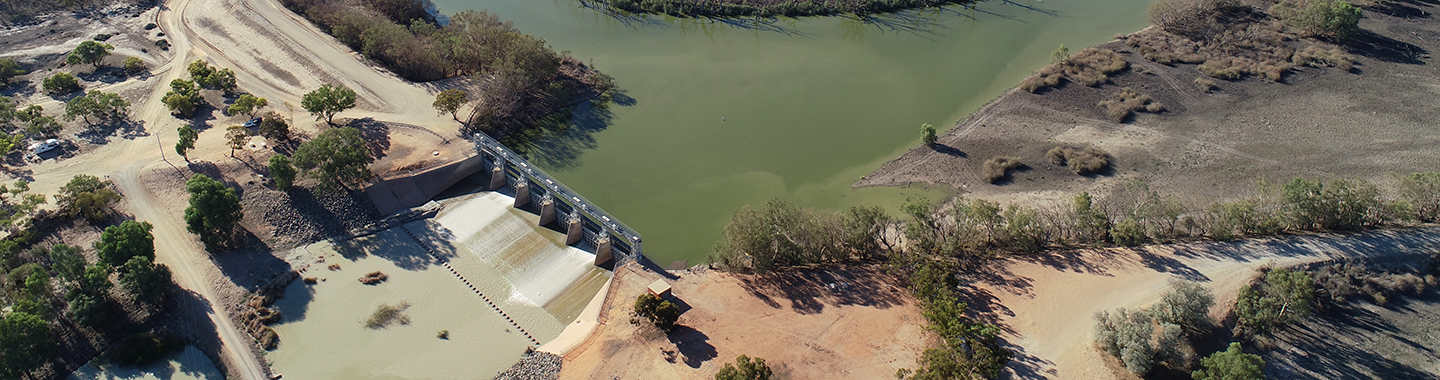
Menindee Lakes Project rescope
The NSW Government is aware of strong elements of community opposition to the Sustainable Diversion Limit (SDL) Adjustment Mechanism project proposed for the Menindee Lakes Project.
Recognising this project has unique sensitivities and cannot be delivered in its current form by 2024, it is currently being rescoped.
There are multiple issues that need to be resolved within the next two months, which is why we will be mobilising additional resources to work on rescoping the project. This will include revising baseline schedules and budgets, as well as carrying out an assessment of the benefits and risks of any potential project.
We are committed to working with communities on delivering projects that will have broad community support.
Community engagement
The NSW Government has carried out a comprehensive program of engagement with the local community and will continue to collaborate and seek input from key governance groups including the Menindee Lower Darling Stakeholder Advisory Group and Technical Advisory Group throughout the life of any project.
Engagement with First Nations people is regarded as critical to the rescoping process and the wider community will also be provided with opportunities to influence any rescoped project.
Aboriginal engagement and cultural significance
The Menindee Lakes, Darling Barka River and Great Darling Anabranch are rich in cultural and archaeological significance. As Traditional Owners, the wisdom and experience of the Barkandji people is critical to informing any potential project on their land.
Water Infrastructure NSW is committed to carrying out comprehensive engagement with the Barkandji to ensure their cultural and spiritual connection to water is thoroughly understood, respected and integrated into project development and delivery.
Menindee Lakes cultural significance
Find out why the Menindee Lakes and Darling River (the Baaka) are so culturally important to the Barkandji people.
Modelling
Hydrologic and hydraulic modelling is being undertaken to inform the rescope process.
Frequently asked questions
Learn more about the Menindee Lakes Project through these frequently asked questions and answers.
How can stakeholders and the community get involved?
The NSW Government will consult extensively with water users and the community around the Menindee Lakes and Lower Darling (including Great Darling Anabranch) on potential future management options for the lakes and the river.
The NSW Government has established a formal Stakeholder Advisory Group. It will enable the exploration of options for the project with representatives to ensure local knowledge is incorporated into the design and outcomes
The wider community will also be consulted through opportunities such as information sessions and formal submission processes.
All engagement activities will be conducted in a timely and transparent manner. Specific dates and details of engagement activities will be communicated
What is the background on water management for the Menindee Lakes?
Before the modification of the lakes in the 1950s and 1960s to provide a storage system, the lakes would naturally fill during high river flows and subsequently recede, forming a series of pools that would go through the natural cycle of wetting and drying. The alteration of the lakes through the addition of weirs, regulators, levees, and channels to allow the storage and release of water has substantially changed this natural regime. On average the Menindee Lakes lose 426 gigalitres of water annually to evaporation. Up to 700 gigalitres can be lost to evaporation annually when the lakes are full.
Each lake also contains a percentage of ‘dead storage’ that cannot be accessed for consumptive use, and may therefore also be lost to evaporation. This “dead storage” is estimated at more than 119 gigalitres for the four main lakes.
If evaporative water loss from the Menindee Lakes could be reduced, significantly more water could be made available for the environment.
As well as being a significant source of water for local towns and users, the lakes are also located in an area of social and cultural significance, and provide recreational, tourism and economic opportunities for the towns and surrounding region.
The Menindee Lakes System is an ecologically significant area of the Murray–Darling Basin, providing key habitat for aquatic fauna, including important nursery grounds and recruitment hotspots that support native fish populations of the Barwon, Darling and Murray Rivers.
Since their modification, the Menindee Lakes have generally been operated to maximise the storage volumes, water quality, and ability to supply users. Since the 1990s, operations have also focused on providing ecological benefits, managing flood mitigation for the Lower Darling to provide environmental benefits, controlling foreshore erosion, and minimising erosion of cultural heritage sites.
Regulation of the lakes has increased sedimentation, reducing accessibility of water, and has also altered the flow regime in the Lower Darling, reducing the frequency of overbank flow events and freshes.
There are a range of ecological targets associated with the flow regime for the Lower Darling floodplain that are currently difficult to meet because of existing operational constraints including regulator capacities and operational policy, and the need to ensure reliability of local town water supply.
Altering the existing operational strategies and constructing new or modified infrastructure has the potential to address many of these issues, while providing water savings to meet NSW’s commitments under the Basin Plan.
How are the Menindee Lakes currently operated?
Since their modification, the Menindee Lakes have generally been operated to maximise the storage volumes, water quality, and ability to supply users, and to minimise evaporation and mitigate floods where possible.
Since the 1990s, operations have also focused on providing ecological benefits, managing flood mitigation for the Lower Darling, controlling foreshore erosion, and minimising erosion of cultural heritage sites.
The Menindee Lakes storage is owned and operated by New South Wales with a long-standing arrangement under the Murray-Darling Basin Agreement. This Agreement requires the Murray-Darling Basin Authority (the MDBA) to include the water held within the lakes as part of the shared resource of the River Murray System, and use the water in the lakes when the volume is above 640 GL until it next falls below 480 GL.
Once the total volume of the lakes falls below 480 GL, the held water is no longer considered a shared resource of the River Murray System and the water is managed by New South Wales to meet local demands. Some of the water within the Menindee Lakes system is considered dead storage and cannot be accessed for release.
To ensure critical water supply needs can be met during periods of low inflows as well as to minimise evaporative water losses, Lakes Wetherell and Pamamaroo are preferentially used to store water ahead of Lakes Menindee and Cawndilla. In most instances, water released to meet immediate consumptive demands comes initially from Lake Menindee, then Lake Cawndilla and Lake Wetherell.
As in other catchments, water is supplied according to the order of priority of licences, particularly during periods where water availability is limited, and use may need to be restricted to protect water for critical needs. This protection of stored water can become particularly crucial as water volumes drop, and as evaporative losses become more significant and water salinity increases.
In an extended period of low inflows, the salinity can become sufficient to make the water in the lakes unsuitable for irrigation or town water supply regardless of availability. It does, however, remain an important refuge habitat for aquatic and terrestrial fauna until the next major inflow.
During periods of flood, the lakes are operated to maintain the structural integrity of existing infrastructure, to maintain the security of existing water entitlements, and to minimise damage to downstream properties where possible.
Inflows are managed based on a series of considerations including water quality, levee bank stability and pre-releases to mimic a more natural flow pattern. Water can also be transferred from Lake Menindee to Lake Victoria in the Lower Murray under a ‘harmony operation’ if flows in the Lower Murray are not meeting consumptive and environmental demands for water. Water for additional dilution flow procedures can also be called from the lakes during periods of storage excess.
Contact us
For more information call us on 1300 081 047 or email us at: winsw.engagement@dpie.nsw.gov.au