Learn about some of the work our groundwater scientists do, to better manage groundwater in NSW:
Cockburn connectivity studies
The department is investigating options for setting a daily cease to pump rule for aquifer access licences in the Cockburn River Alluvium Management Zone in the Peel Alluvium Groundwater Source.
The Water Sharing Plan for the Namoi Alluvial Groundwater Sources 2020 allows groundwater access rules to be established after 1 July 2022.
A Review (PDF, 37238.49 KB) of Groundwater-Surface Water Connectivity - Cockburn Alluvium Management Zone completed in June 2019 confirmed that:
- groundwater in the alluvial aquifer is highly connected to the surface water of the Cockburn River
- groundwater extraction has the potential to impact on the flows and pool volumes in the Cockburn River, and
- there is no current short-term alternative cease-to-pump trigger points.
While this review showed groundwater and surface water in this area is highly connected, we want to better understand the effect of groundwater extraction on the surface water pools and habitat for endangered populations of Eel-tailed catfish and Murray cod.
The department is now undertaking further work to investigate the relationship between groundwater extraction and surface water pools in the Cockburn River Alluvium Management Zone.
The Cockburn River groundwater and surface water connectivity study – progress report (PDF, 37238.49 KB) provides information on study sites, data collected to date and the next steps of the study.
The department will consider the study findings when developing options for groundwater access rules before consulting with stakeholders on their views. Details on the findings of the study are in the Cockburn River Groundwater and Surface Water Connectivity Study (PDF, 6890.34 KB).
Maroota extractive industry groundwater study
A study in 2018 looked into groundwater levels in the Maroota locality northwest of Sydney. Maroota supports a variety of land uses:
- agriculture
- market gardens
- National Park
- State Forest
- extractive industry (sand mining/quarrying).
Sand mining/quarrying in Maroota is growing because of increasing demand for construction material for use in Sydney and other areas.
The groundwater investigation assessed potential impacts on the aquifers in the Maroota area. The study used groundwater level data to determine a baseline. This helps to make sure quarries stay above the groundwater table and not interfere with groundwater withdrawal by other nearby users. The results can be used to provide a more consistent approach to the assessment of development applications for quarries in the Maroota area.
Read the Maroota groundwater study fact sheet (PDF, 660.04 KB) or the full Maroota Extractive Industry Groundwater Study (PDF, 15082.78 KB) report for more information about the study and its results.
Ground displacements in New South Wales
Below the land surface, groundwater is found in tiny spaces known as ‘pores’ between grains of sand and gravel, and in clay. Sand, gravel and clay are also called sediments. Groundwater can help to support the structure of sediments by filling these tiny pore spaces. If the groundwater level drops by too much for too long, this can cause pore spaces to collapse. This can then cause compaction of the sediments. Compaction over a large area permanently reduces the size and amount of pore spaces between the sediments. This reduces the amount of groundwater that can be stored in that area. In some cases, compaction can lead to land subsidence. This is where the land surface sinks as the sediments underground have moved. Land subsidence is also known as ground displacements.
On the behalf of the department, CSIRO studied the impact of groundwater extraction on ground displacements in the Lower Namoi groundwater source and groundwater sources in southern inland NSW including the Murray, Murrumbidgee and Lachlan. To investigate ground displacements, CSIRO compared several datasets: surveyed benchmarks, historical groundwater levels, and remote sensing radar imagery (Interferometric Synthetic Aperture Radar (InSAR)
For the Lower Namoi, the study found that some land subsidence has occurred during the 45 years of field benchmark data. However, there is no identifiable land subsidence that can be attributed to groundwater extraction during the three-year period from 2015 to 2018 during which the InSAR analysis was done. The land displacement during this three-year period appears to be due to periodic surficial shrinking / swelling of clays which is expected in this area. Read more about Ground displacements in the Lower Namoi region (PDF, 37238.49 KB).
For the southern inland areas, the study found land subsidence of up to 30 mm/yr in some isolated areas near Hilston and Coleambally due to groundwater extraction. However, some of this subsidence could have occurred prior to the study, such as during the Millennium drought when groundwater levels were dropping due to groundwater extraction and the significant dry climate. Read more about Ground displacements over alluvial aquifers in southern inland NSW (PDF, 39016.31 KB).
This work is a benchmark for future studies into land subsidence in NSW. The knowledge gained from this work will benefit other areas of the State where land subsidence is a risk.
Bottled water review
Some communities have raised concerns about the use of groundwater in the bottled water industry. In response to community concern, the NSW Chief Scientist & Engineer undertook an independent review into the impacts of the bottled water industry on groundwater resources in the Northern Rivers region of NSW.
The independent review's final report includes advice on the sustainability of groundwater extraction limits in the Northern Rivers, as well as advice on monitoring groundwater at both the regional scale and at the local scale of extraction operations.
The NSW Chief Scientist & Engineer’s final report in December 2019 is available on the NSW Chief Scientist & Engineer website.
The review found that groundwater extraction by the bottled water industry is quite small, representing 0.55% of the total volume of water licences and basic landholder rights for groundwater sources in the Northern Rivers region. It found that the Water Sharing Plan that sets out rules to help manage potential impacts from groundwater extraction is appropriately conservative. Although there are tools in place to manage potential impacts from groundwater extraction, improvements can still be made by improving transparency around assessment processes and publication of information.
The department has made progress on implementing the review’s seven recommendations. The status of each recommendation as of end June 2023 is in the below table.
| Recommendation | Status |
|---|---|
| 1. Further work is undertaken to incorporate climate change into the development of recharge estimates for the water sharing plan. | Closed: There are actions within the NSW Water Strategy, NSW Groundwater Strategy and the relevant regional water strategy that seek to incorporate climate change considerations into the water sharing plan framework in future. As this climate change work progresses, future water sharing plan reviews provide a structured and regular regulatory opportunity to assess and build in any changes recommended as an outcome of these broader actions. |
| 2. Consideration should be given to incorporate geological heterogeneity and soil and vegetation types into recharge estimates where practicable. This may be dependent in part on technological advances, including remote sensing, to characterise systems. | Closed: The current approach to estimate recharge for setting the water sharing plan extraction limit takes into consideration the variability in the geology across a water source. |
| 3. Improved monitoring of piezometric water levels is needed in locations with a perceived risk and/or lack of knowledge of groundwater responses and low directions. This could provide baseline data, conceptual hydrogeological models and recharge estimates commensurate with potential future risk levels. Additional investments in monitoring should balance the value of expected improvements in data availability and data quality against the resources required. | Closed: The NSW Government groundwater level monitoring programs are focused in areas where there are significant levels of extraction. The Alstonville Basalt Plateau Groundwater Source west of Ballina is one of these areas. Groundwater level data is available on the WaterNSW Real Time
Data website.
It is unlikely that investment in new public monitoring infrastructure will occur in the short term in other areas of the Northern Rivers Region as they are not areas with high levels of groundwater extraction. Further consideration is needed regarding making the groundwater level data from these monitoring bores public. The department will consider this as part of the implementation of its open data framework. |
| 4. Robust local assessments of aquifer connectivity with overlying shallow groundwater and surface water should be investigated via well-designed pump tests. This information should feature in hydrogeological reports. | Closed: A site-specific pumping test data including analysis of aquifer parameters and the raw data is recommended, the department may also request one to better inform impact assessment. The proponent would bear the cost of the pump test in line with the department’s published pump test guideline. |
| 5. Work should continue towards developing practical and comprehensive guidance on the contents of hydrogeology reports to be submitted by proponents, including specificity and standardisation of information provided and reporting requirements. Ideally, these would be able to be lodged electronically and made publicly available. | Closed: The department has completed developing a guidance document on what water bottling proponents are required to address in their applications for development consent. This has been published in 2024.
The department published technical guidelines on Minimum requirements for integrated development that includes water supply from groundwater (PDF, 389.21 KB). |
| 6. State government agencies and local government should work to clarify roles and responsibilities to streamline assessment and approval processes, to avoid duplication of effort, and to address any gaps in the assessment and approvals process The first step for this would be by February 2020, relevant officers from WaterNSW, the department, NRAR and Tweed Council convene a workshop for Northern Rivers region bottled water to discuss and develop an approach between them. | Closed: A workshop in the Northern Rivers was initially delayed due to bushfires and COVID. Since then, Tweed Shire Council amended its LEP to prevent the establishment of new water bottling operations. As such, there is no immediate need for this workshop with Tweed Council. More broadly, the department has been liaising with stakeholders on issues that may require further discussion. |
| 7. Water extraction and monitoring data should be made available in standardised formats through open and accessible portals. State managed databases and portals (e.g. SEED) should be utilised where relevant. | In Progress: The department’s Data and Information team undertook data discovery to identify relevant data held. Analysis of the relevant data has determined that the department is not the custodian of this data. The data is held by local councils. The department investigated the options that would allow councils to share this data and have identified that SEED is a viable solution. |
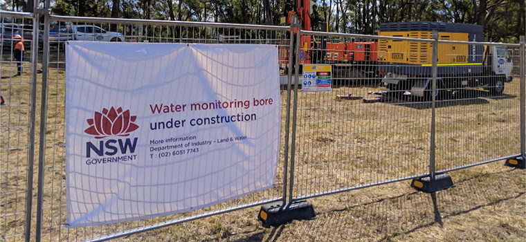
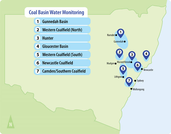
Water Monitoring Strategy – NSW Coal Basins
The Water Monitoring Strategy for Coal Basins in NSW was developed to improve our understanding of groundwater behaviour in the NSW coal-bearing geological basins.
The NSW Government committed $22 million to deliver the strategy, and in 2021 it was completed when 79 groundwater bores in coal basins were added to its groundwater monitoring network.
Data from the ongoing monitoring of these bores will be uploaded, and accessible through WaterNSW. Water levels, pressure and salinity of the bores are being monitored, and they will be regularly sampled for water quality analysis.
The groundwater data collected will help identify the potential effects of extractive industries on water resources in NSW coal basins.
The data also allowed the department to gather more information to better map, monitor and manage groundwater. Read more on the project and the water monitoring network expansion (PDF, 179.13 KB).
For more information contact Rob Brownbill, Lead Hydrogeologist, Department of Planning and Environment on 0428 688 954.
Billabong Creek salt interception scheme
In 1997, the Billabong Creek catchment was identified as having high salt loads in its upper reaches. That would increase salt loads and concentrations in the creek over the next 50 years.
The potential impact would see increased salinity levels in the Billabong Creek and in the Murray River. This would increase electrical conductivity by 3.9 EC units at Morgan, South Australia. Electrical conductivity is a measure of salinity concentration. Morgan is the point of measurement for the Murray-Darling Basin Salinity Strategy.
Where is Billabong Creek?
Billabong Creek is the longest creek in the world. It is located in southern NSW. The creek rises east of Holbrook. It flows to the west for about 320 kilometres before entering the Edward River at Moulamein.
The salt interception scheme is located adjacent to Billabong Creek at Morgan's Lookout immediately north of Walla Walla, about 50 kilometres north of Albury.
How does the scheme work?
The Billabong Creek Salt Interception Scheme consists of a bore that pumps freshwater (less than 930 EC) from a deep aquifer, about 80 metres below the ground, directly into the creek.
Up to 1,500 megalitres of groundwater per year is pumped when the natural flow in the creek is low. This reduces the upward pressure of the deep aquifer that is forcing saline water (about 5,000 EC) from the shallow aquifer into the creek.
Freshwater from the deep aquifer is also made available to local farmers from a standing pipe on the site.
The scheme prevents about 3,000 tonnes of salt each year from entering Billabong Creek and the Murray River.
An additional component of the scheme is the establishment of a wildlife corridor that connects the Billabong Creek at the site of the scheme with Gum Swamp about one kilometre to the east. Both of these areas have high conservation values.
Why is there a problem?
Saline water in the shallow groundwater aquifer flows into the Billabong Creek along a two kilometre stretch near Morgan's Lookout, where the creek intersects with the shallow aquifer.
The palaeochannel, or ancient channel, that contains the deep freshwater aquifer is constricted by the geology that pushes it upward, forcing the saline water in the shallow aquifer into the creek.
What will the scheme achieve?
The Billabong Salt Interception Scheme will lower the salt load in the creek by 3,000 tonnes per year which, together with the wildlife corridor, will provide significant water quality and environmental benefits.
The scheme is estimated to reduce the salinity at Morgan, South Australia by 0.1 EC.
Good quality water is pumped into Billabong Creek, offsetting the impacts of diversions and water used for stock and domestic purposes upstream. This additional water benefits the ecology of the creek and provides water to downstream users who rely on the creek for stock, domestic and commercial supplies.
The region's biodiversity is enhanced by the establishment of a corridor of native vegetation. The maintenance of native vegetation and protection of the region's biodiversity has been identified as one of the key natural resource issues to be addressed within the Murray catchment.
The salt interception scheme is situated between the Walla Swamp and the Billabong Creek, both of which are important biodiversity 'hotspots' within the Murray catchment.
The scheme also provides a major socio-economic benefit to the region.
Who operates the scheme?
An agreement has been reached between the NSW Government through the NSW Office of Water (and the former Department of Environment, Climate Change and Water), and the Norske Skog Paper Mill at Albury. The Billabong Creek Green Offsets Project will allow Norske Skog to discharge a limited volume of moderately low strength saline process water into the Murray River, in return for funding the operation and maintenance of the Billabong Creek Salt Interception Scheme.
This joint initiative allows Norske Skog to maintain and develop its current operation, injecting over $100 million each year into the local economy, whilst maintaining a 0.1 EC benefit at Morgan. This allows for the creation and maintenance of jobs in a rural economy.
Overall, reduced salinity levels in the Murray River are critical for the environment and downstream water users as far as South Australia.
Benefits at a glance
Local
- Enhanced vegetation and biodiversity with re-established corridor between Morgan's Lookout and Gum Swamp
- Improved water quality and the provision of stock and domestic water for users in the Billabong Creek.
Regional
- Increased flows in the Billabong Creek
- Secures Norske Skog's operations
- Increased regional employment opportunities.
Basin wide
- Reduced overall salinity levels in the Murray River as measured at Morgan, South Australia.